West Bond via Zeacliff Hike – Trail Guide & Trip Report (White Mountains, NH)

White Mountains, New Hampshire · 44.17°N 71.52°W
West
Bond
Zealand Road → Zealand Falls → Zeacliff → West Bond → Return
- Dist
- 22.84 mi
- Gain
- 4,253′
- Time
- 8:01
The Trail
West Bond earns its remoteness. The Zealand approach threads through one of the wildest corners of the Pemigewasset Wilderness — a long valley walk, a steep ridge climb past Zeacliff, and a high exposed traverse before the summit spur. Over 22 miles round trip, it's one of the most committing day hikes in New Hampshire.
West Bond sits at 4,540 feet at the far end of the Bond range, deep in the Pemigewasset Wilderness of White Mountain National Forest. There's no easy way in. The Zealand approach is the longest, gentlest, and most beautiful: a flat valley trail past Zealand Falls Hut, then a steep climb up the Zeacliff Trail to the high ridge, and finally a long ridgeline traverse to reach the summit spur.
The scale of this hike is what makes it memorable. The first few miles barely register — wide, well-maintained trail through boreal forest alongside a gentle stream. Then the Zeacliff climb hits fast and doesn't let up. By the time you reach the exposed ridge, you've already earned the views. The summit itself is a narrow, airy perch with nothing between you and the surrounding peaks in any direction.

FROM THE TRAIL JOURNAL
Field Notes
Started at first light from the Zealand Road trailhead, the forest still cool and quiet. The early miles rolled easily along the valley — that flat approach is deceptive. It lulls you into a comfortable pace before the Zeacliff climb arrives and reminds you exactly what you signed up for.
The ridge walk above treeline was everything I'd hoped for. After miles of forest, the Pemi opened up in every direction — the Bonds, Franconia Ridge, the Twins — all of it spread out under a clear July sky. West Bond's summit felt genuinely earned in a way that shorter hikes rarely do.
The Pemi rewards patience — a summit this remote has to be earned mile by mile, and there's no better reminder of that than the long, quiet walk back out.
— Anton
Trail Diary
Zealand Road Trailhead
Set off from the Zealand Road trailhead just after seven, the forest still cool and the sky clear. The first section of the Zealand Trail is flat and wide — more of a walk-in than a hike — which made for a relaxed start on what would be a very long day.

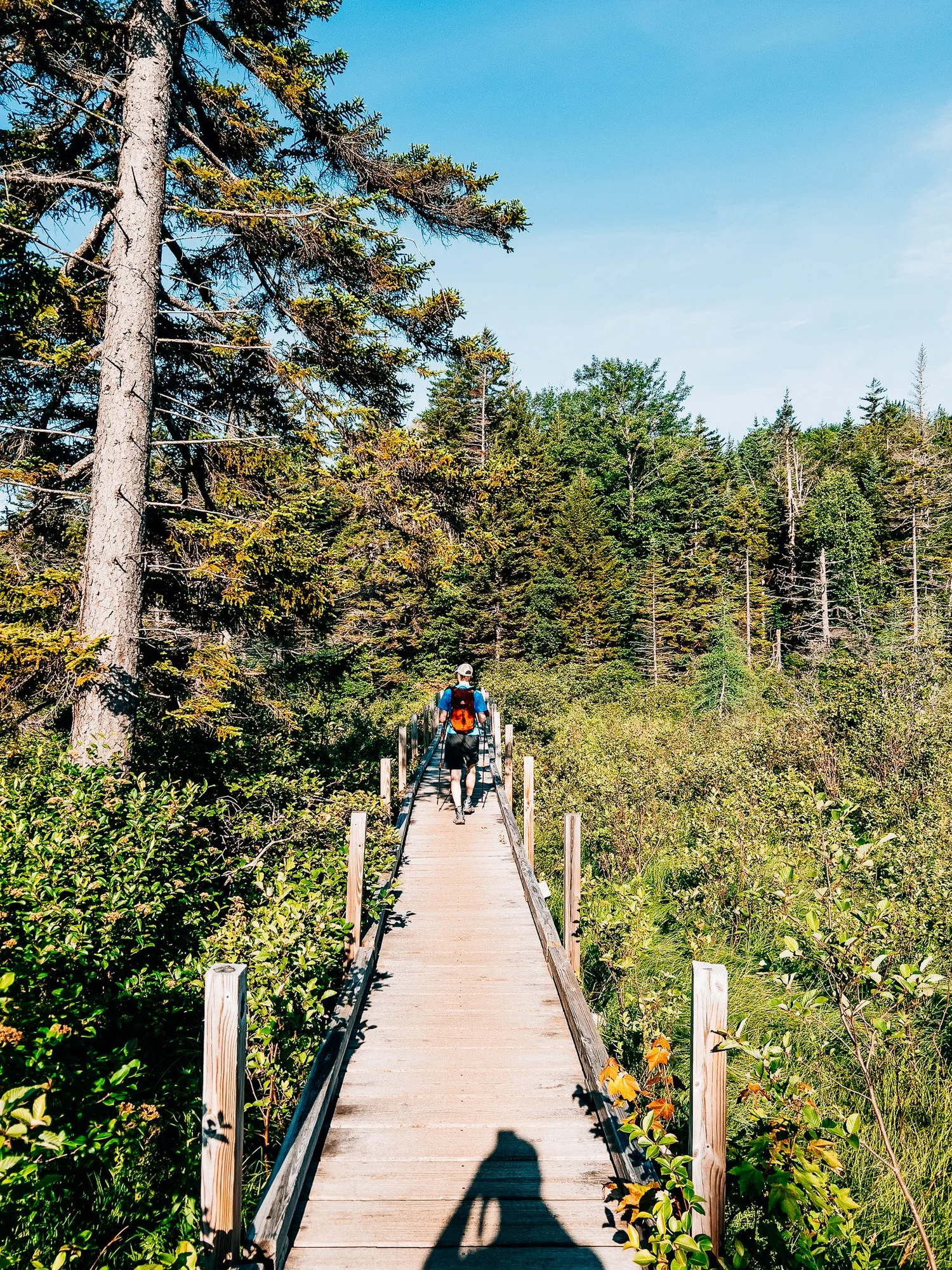
Zealand Valley
The trail opened up into the Zealand Flats — long wooden boardwalks threading through wetlands, a still pond reflecting the ridge above. One of the most peaceful stretches of trail in New Hampshire, and all of it before breakfast.


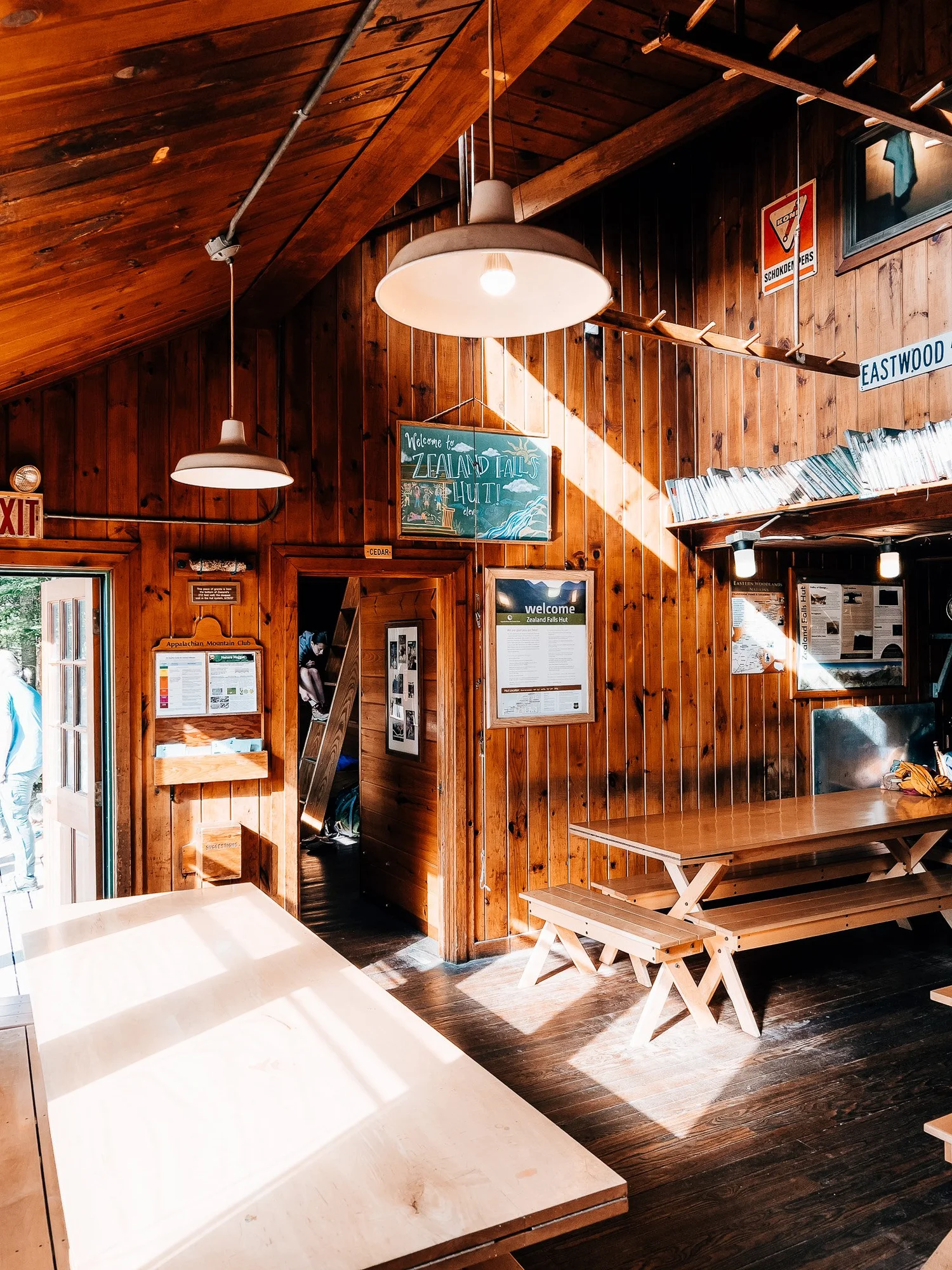
Zealand Falls Hut
Passed through Zealand Falls Hut — one of the AMC's most beautiful backcountry huts, perched above the falls at 2,630 feet. The hut was just stirring awake at this hour. Grabbed some water from the falls and kept moving.

Zeacliff Climb
The Zeacliff Trail broke from the valley and pitched steeply uphill — over 1,300 feet in under a mile. The trail surface went from dirt path to wet rock to stone steps as the forest slowly gave way to thinning spruce and light. This is where the day's character changed completely.


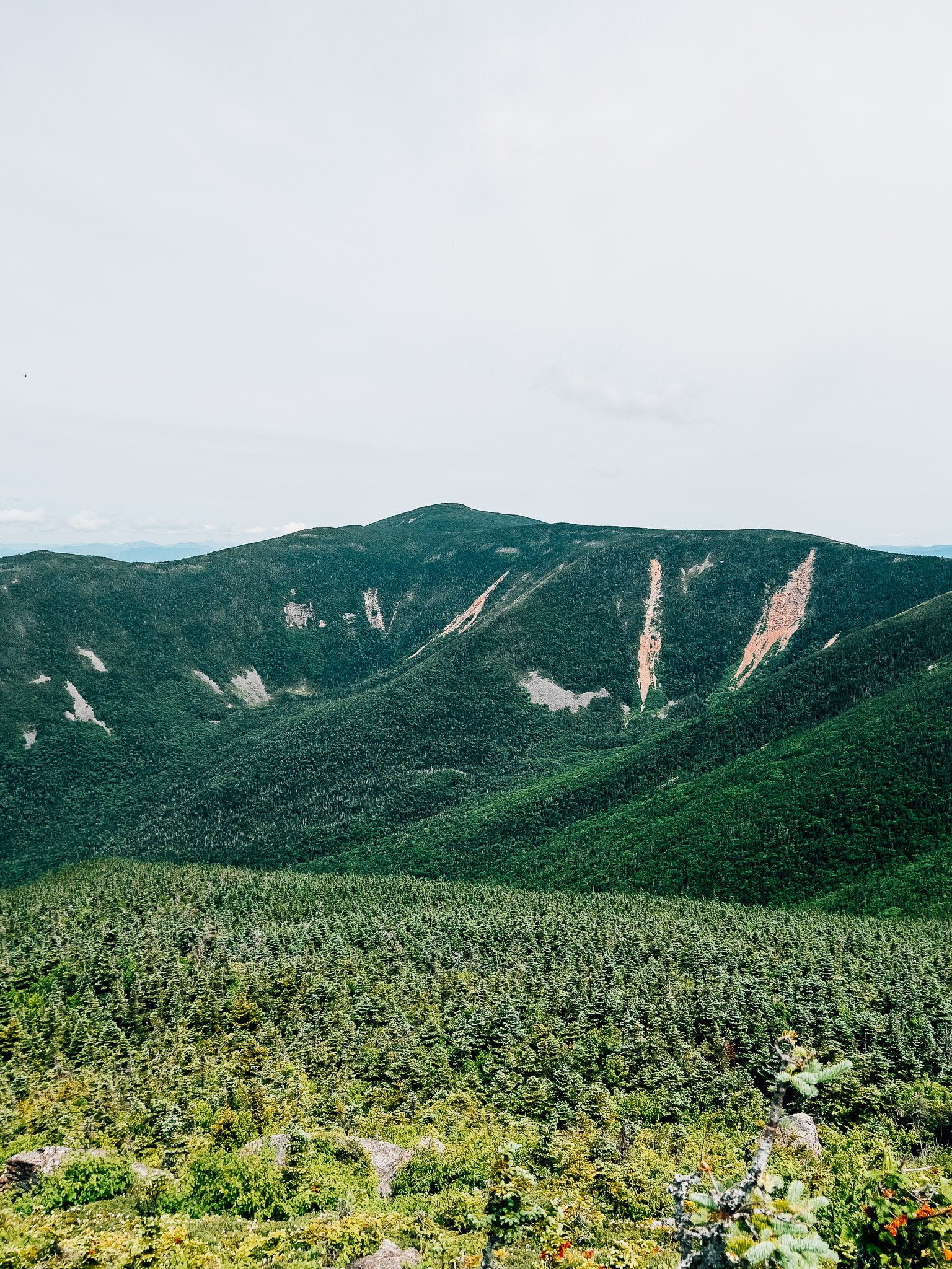
Zeacliff Outlook
Topped out on the Zeacliff ledges and the Pemigewasset Wilderness spread out below — a sea of green ridgelines with nothing built in any direction. This is one of the finest viewpoints in the White Mountains, and I had it completely to myself.


High Ridge
The Twinway carried me across the high ridge, above treeline and fully exposed. The terrain shifted from dark spruce forest to open rocky alpine — diapensia in bloom between the boulders, the Bond range stretched out ahead. The Pemi looked enormous from up here.


Bondcliff Trail Junction
Hit the Bondcliff Trail junction and turned down toward West Bond. At this point it's still 0.7 miles to Mt. Bond and Lincoln Woods is over 5 miles away — a good reminder of just how deep in the wilderness this is.

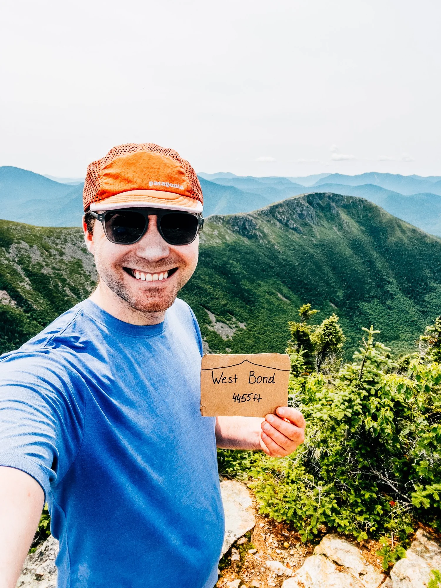
West Bond Summit — 4,540 ft
The summit spur is short but steep, finishing on a narrow rocky crown with 360° views. Franconia Ridge to the west, the Twins to the north, Bondcliff dropping away below — one of the finest spots in the White Mountains, and the most work to reach.


Back at the Trailhead
Eight hours and twenty-two miles later, back at the car. The flat valley miles on the return are a gift — shaded, peaceful, and just long enough to process the day. The Zealand approach earns its reputation: big mileage, but never cruel, and every one of those miles felt worth it.
Hike Summary
- Name
- West Bond
- Location
- Pemigewasset Wilderness, White Mountain National Forest, NH
- Route
- Zealand Road → Zealand Trail → Zeacliff Trail → Twinway → Bondcliff Trail → West Bond Spur → Summit (out & back)
- Distance
- 22.84 miles
- Elevation Gain
- 4,253 feet
- Total Time
- 8 hrs 1 min
- Class
- Class 2
- Access
- Zealand Notch Trailhead. Well-maintained, seasonal 2WD road.
Trail Features
What you'll find along the way —
-
01
Zealand Valley Approach
The first five miles follow a flat, wide trail through boreal forest — boardwalks over wetlands, a still pond, and Zealand Falls Hut before the real climbing begins.
-
02
Zeacliff
One of the most dramatic viewpoints in the White Mountains — exposed ledges overlooking a sweeping drop into the Pemigewasset Wilderness below.
-
03
Alpine Wildflowers & Tundra
The stretch between Zealand Falls and Mt. Guyot passes through a beautiful open alpine tundra — diapensia, bog laurel, and krummholz giving way to wide sky and long views.
-
04
Peak Bagging Opportunity
For those up for a big day, this route connects easily to Mt. Bond, Bondcliff, Mt. Guyot, and Zealand Mountain — four or five summits in a single push from the same trailhead.
-
05
360° Summit Views
West Bond's narrow rocky crown offers a true wilderness panorama — Franconia Ridge, the Twins, and the full sweep of the Pemigewasset with no roads or buildings in sight.
Recorded with Strava
Open Activity Recorded with Strava
Gallery


Until the next ridge,
Anton
Follow the trail @antonpugphoto →

Disclaimer
Everything you find here, whether it's a hiking guide or a trail story, is meant for inspiration, not instruction. I'm not a guide, and I'm not responsible for what happens if you decide to follow a wrong turn or take on more trail than you're ready for.
The outdoors can be unpredictable, so always use your own judgment, check official resources, and know your limits. By using this site, you agree it's all at your own risk. Take what inspires you, leave what doesn't, and go make it your own adventure.
Enjoyed the trip report? Pass it along to a hiking partner.